In today's blog article, we will present some insights into the remote-sensing observations that were (and partly are still being) performed at the Tāwhaki site, several hundred kilometers north of the goSouth-2 main site at Invercargill. Both of these sites are connected by the ACADIA project, a German Science Foundation funded initiative. See below for more details!
Clouds over the Southern Ocean play an important role in the climate system, yet they remain difficult to understand. Although these clouds strongly influence the Earth’s radiation balance, their accurate representation in weather and climate models is still difficult. Within the ACADIA (Aerosol-Cloud-rADiation-interaction over Aotearoa) project, we conduct a comprehensive ground-based observation campaign in New Zealand Aotearoa to improve our understanding of Southern Ocean clouds and aerosol–cloud interactions. The project constitutes a long-term international collaboration between Leipzig University (PI Heike Kalesse-Los), TROPOS (PI Patric Seifert) , and University of Canterbury (PI Adrian McDonald).
Observations within the frame of ACADIA are performed at two sites. Besides goSouth-2 observations with the TROPOS-LACROS suite at the MetService site in Invercargill, we use the Tāwhaki National Aerospace Centre as a key observational site (https://tawhaki.co.nz/tawhaki-national-aerospace-centre/). Tāwhaki is located on the east coast of New Zealand’s South Island near Christchurch (Fig. 1). At this site, we operate several remote-sensing instruments to continuously monitor clouds and precipitation, and atmospheric conditions.
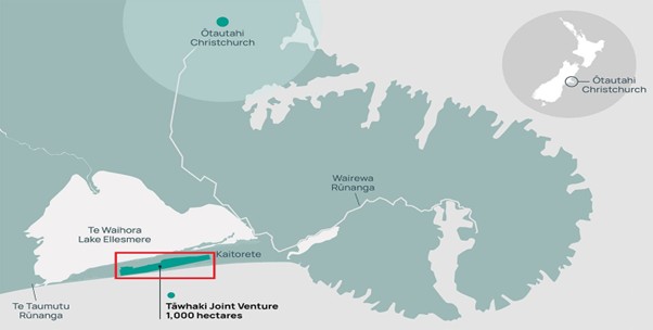
Figure 1 Location of the Tāwhaki National Aerospace Centre relative to Christchurch, New Zealand. Map adapted from the Tāwhaki National Aerospace Centre website.
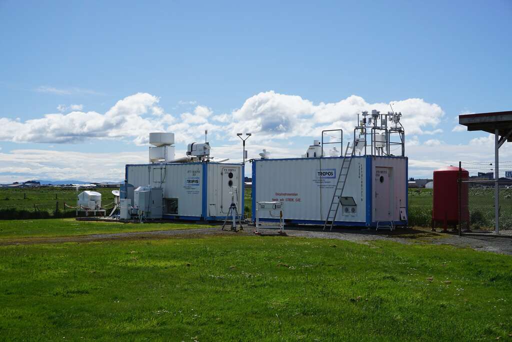
Fig. 2 shows an overview of the deployed instrumentation at Tāwhaki. W-band Doppler cloud radar observations by Leipzig University were conducted from September 2025 to January 2026. University of Canterbury installed a CL61 depolarization ceilometer, a micro rain radar, a wind lidar and a disdrometer. Operations of these instruments are ongoing and in future the deployment of new additional instruments is foreseen, e.g., to collect filter samples of surface-near aerosols, or to perform tethered-balloon measurements. With this complementary instrumentation suite, we will investigate cloud microphysics, hydrometeor types, and precipitation formation in Southern Ocean air masses. Specific focus will be put on investigating the effect of clean-marine air masses from the Southern Ocean vs. aerosol-rich air masses from Australia containing dust and potentially wildfire smoke on cloud and precipitation formation processes.
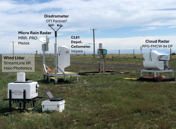
Figure 2 Ground-based remote-sensing instruments at the Tāwhaki National Aerospace Centre in New Zealand monitoring clouds, precipitation, and atmospheric conditions as part of the ACADIA field campaign (Photo by H. Kalesse-Los).
The observations at Tāwhaki are closely coordinated with measurements at the Invercargill site and with other field campaigns such as the HALO-South aircraft campaign (Sep–Oct 2025). Specifically, ground-based support by ACADIA for the aircraft campaign was complemented by 40 radiosonde launches providing a comprehensive view of the atmosphere over the Southern Ocean (Fig. 3).
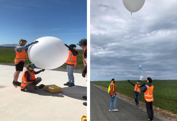
Figure 3 Radiosonde balloon preparation and launch at the Tāwhaki (Photo collage by H. Kalesse-Los).
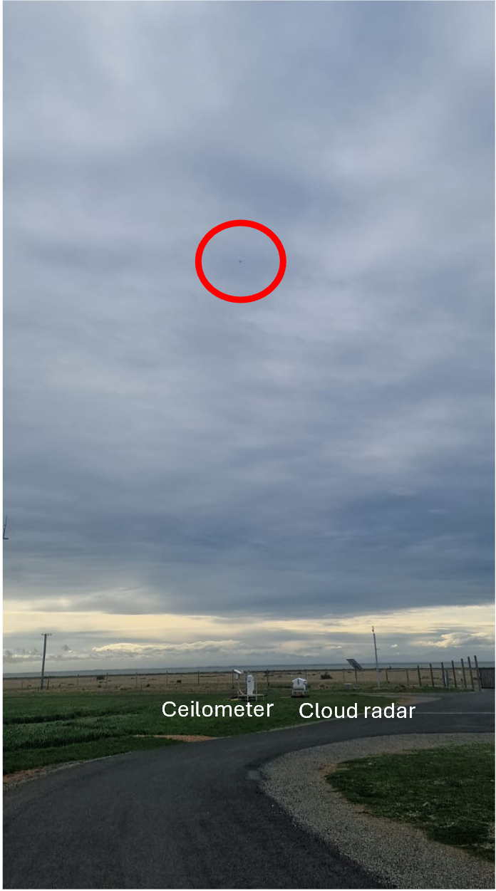
Figure 4 Overpass of the HALO research aircraft during the HALO-South campaign above the Tāwhaki site.
The observations collected at Tāwhaki will continue to support exciting research further. The analyses now underway will help us better understand the processes shaping clouds and precipitation over the Southern Ocean.
Authors: Heike Kalesse-Los, Gautami Niwane
Severe winds caused devastation and widespread power outages in New Zealand on 23 October 2025. Torn-off roofs and fallen trees dominated the news in the following days. Fortunately, there was no significant damage at our remote-sensing platform LACROS and the brief interruption of power and internet was also overcome. To the involved meteorologists in GoSouth-2, this rare event represents the next measurement highlight, as LACROS was able to observe the cyclone throughout its entire passage over the station. The atmospheric system is known among experts as a Shapiro-Keyser cyclone – a special form of the classical cyclone described by the Norwegian model, which frequently occurs over Germany, for example.
The front reached the measurement site at 22:52 UTC on 22 October 2025.
The Shapiro-Keyser cyclone model
The Shapiro-Keyser cyclone differs from the Norwegian cyclone type by means of a much more rapid deepening of its surface low during the intensification stage. This behavior results from a different vertical structure compared to the Norwegian cyclone. A distinctive feature of a Shapiro-Keyser cyclone is the sting jet, which can produce extremely high wind speeds near the cyclone center. At the time of its passage over LACROS, the system appeared to have nearly reached its mature stage. More detailled information about the Shapiro-Keyser cyclone life cycle can be found here.
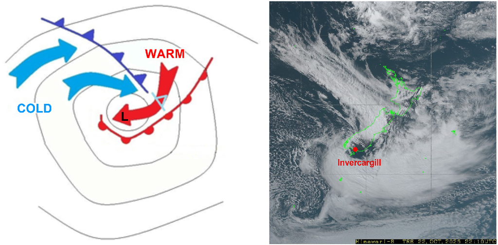
Scheme of a Shapiro-Keyser cyclone during its mature stage (left) and HIMAWARI satellite True-Color-RGB image on 22 October 2025 at 22 UTC (right). The scheme was adapted from https://resources.eumetrain.org/ (last access: 10 November 2025).
Measurements
During the passage of the front at around 23 UTC, wind gusts with 137 km/h (74 kn) and 10-minutes average surface winds of 102 km/h (55 kn) were recorded at Invercargill airport close to the MetService site. Those numbers are marking records at Invercargill for the last 28 years. A wind profile measured by the LACROS Doppler lidar SKIPPER indicates the rapid velocity changes across the lower few kilometers above the site. Average wind speeds of up to 80 kn in the lowest height bin are only rarely observed.
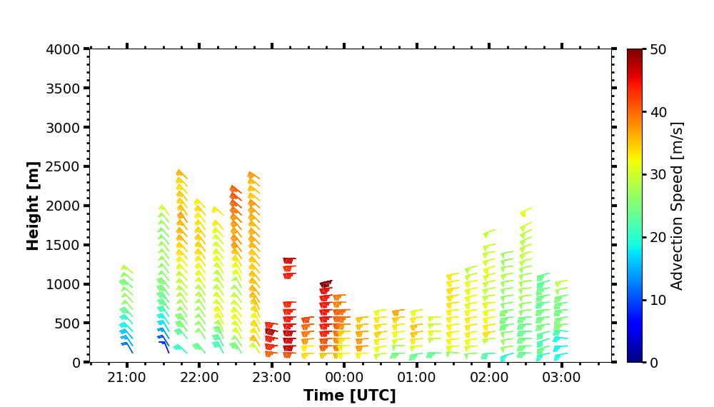
Horizontal wind velocities above LACROS during the storm passage detected by Doppler lidar. Data are not shown above heights where attenuation of the laser beam was too strong.
Also, the observations from one of the LACROS cloud radars (Mira-35) showed impressive observational features. The arrival of the front at 22:52 UTC is marked by high radar reflectivities of up to 30 dBZ at around 3 km height (with attenuation effects at greater heights) and highly turbulent conditions with strong updraft velocities as indicated in the Mira-35 vertical-velocity display. The front was accompanied with a bow-shaped cloud field which is a signature for a very strong free-tropospheric dry-air intrusion. The front passage was also related to a 1000-meter drop of the 0°C level, as can be seen by the shift of the high-velocity rain band from heights of 2000 m down to heights of 1000 m shortly past 23:00 UTC. Last but not least, extreme rainfall rates higher than 250 mm per hour were recorded by the Parsivel² disdrometer, albeit that parts of this extremely high value was caused by flying debris which passed the probing volume of the disdrometer. Nevertheless, the official MetService 1-minute rainfall rate measurement at Invercargill Airport still indicated around 100 mm/h.
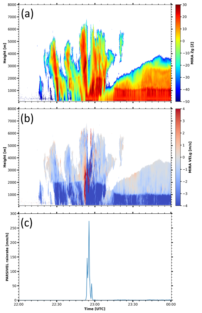
Reflectivity factor (a) and vertical velocity (b) of the MIRA-35 Doppler cloud radar, as well as the surface precipitation rate detected by the Parsivel² disdrometer (c) during the front passage.
Reference and further information:
https://resources.eumetrain.org/satmanu/CMs/SKCycl/print.htm
After the setup of our remote sensing station LACROS in Waihōpai/Invercargill, which luckily went just as planned, the goSouth-2 campaign officially started on 3 September 2025. Continuous observations are already paying off by creating a rich dataset with great potential to reveal new insights into the atmosphere of southern Aotearoa/New Zealand.
Promising LACROS observations during the first two months
The first weeks of operation already yielded successful and promising measurement data of all deployed instruments. The station is running well and except for a one-week measurement interruption of the cloud condensation nuclei counter (CCNC), continuous observations are now available. Local weather at Invercargill these days is characterized by regular rain and graupel showers, sunny hours in between, and typically moderate to strong westerly winds. The latter enable novel observations of marine-dominated aerosol layers above LACROS which will help to achieve one of the big campaign goals - to investigate the contrast between Southern Ocean and Australian air masses. Our whole team is excited about the upcoming data analysis of the first southern hemisphere fluorescence measurements with our lidar PollyXT.
The Leipzig Aerosol and Cloud Remote Observations System (LACROS) at the MetService site at Invercargill
Cooperation with MetService New Zealand
The goSouth-2 campaign benefits from several partnerships with New Zealand institutions. LACROS operates at the site of the MetService close to the airport at Waihōpai/Invercargill. MetService as our host not only provides space for our containers but all essential facilities and infrastructure which is necessary for a successful deployment of LACROS. Further, MetService conducts decade-long observations the atmospheric state above the station, for example, by means of radiosonde launches twice a day. Those timeseries will allow to put the goSouth-2 observations into context and help to meet the research goals of goSouth-2. Vice versa, measurement data of TROPOS, such as profiles of horizontal wind by our Doppler lidar, are shared with MetService and the local airport authorities as well.
HALO-South: aircraft campaign in parallel
The LACROS setup was achieved in time of the beginning of the HALO-South aircraft campaign, where the German reasearch aircraft HALO operated out of Christchurch to probe trace gases, aersols and clouds over the Southern Ocean. Conveniently located en-route, the ground site was overpassed multiple times successfully.
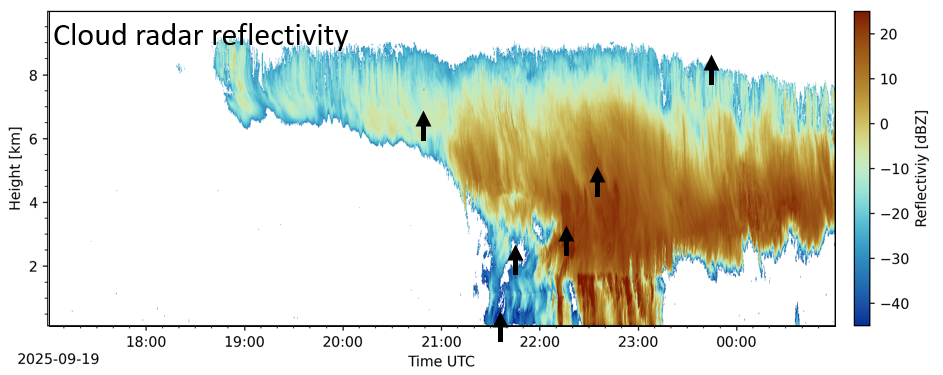
Precipitation system on 19 September 2025 detected by the MIRA-35 cloud radar. Several HALO overflights are indicated by the black arrows. Figure: Martin Radenz
A final highlight during the last week of their campaign were two refuelling stops at Invercargill Airport. Refuelling closer to the target areas allows for longer time above the target regions over the ocean. During the short visit, aircraft and crew were welcomed by the LACROS and MetService team.
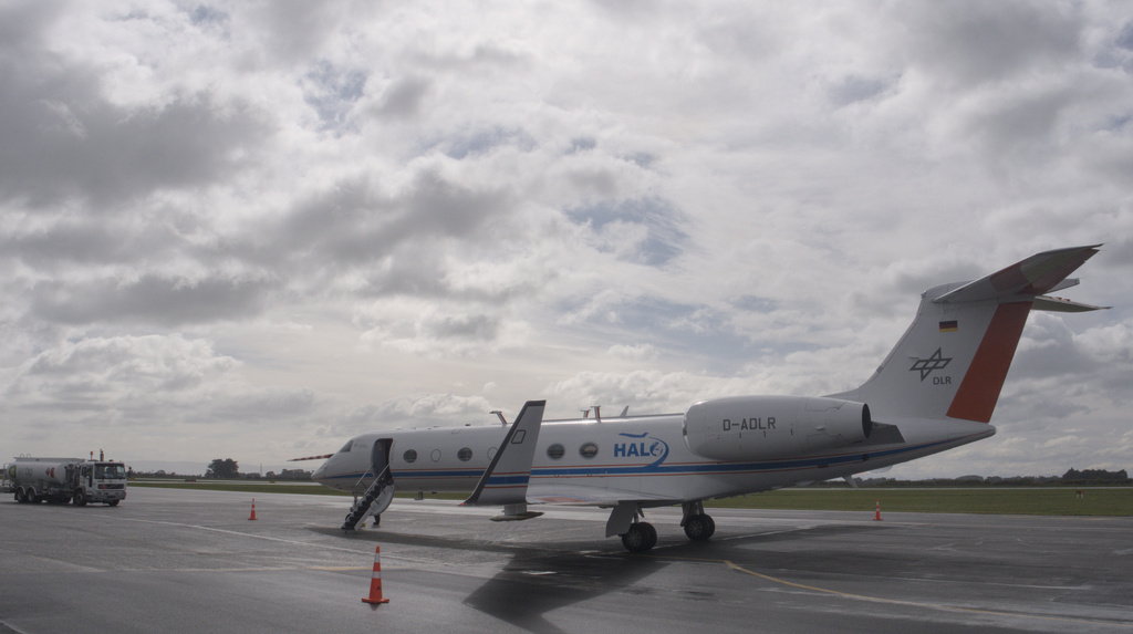
HALO fuel stop at Invercargill airport on 7 October 2025.
Complementing Measurements by the EarthCARE Satellite
Another objective of LACROS in the southern hemisphere mid-latitudes is ground support of EarthCARE. On board that satellite, which is operated by JAXA and ESA, are a lidar, a cloud radar and two imagers, providing comparable measurements to LACROS with a global coverage. Regular overpasses within a distance of only a few kilometres to our station receive special attention as no comparable ground observations for a validation of EarthCARE in this part of the globe exist. Together with the in-situ observations of HALO-South around our stations, a truly unique dataset was acquired so far which is an achievement and something all involved actors can be proud of.
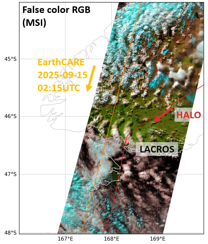
Concurrent EarthCARE and HALO overflights on 15 September 2025 enabled promising simultaneous remote-sensing and in-situ observations of atmospheric constituents and processes. Figure: Martin Radenz
Already within the first weeks after the start of the measurements, impressive examples of some of the scenarios which are targeted within goSouth-2 were observed. We list some of them below to provide you with an impression.
Our measurements from 25 August 2025 (see Fig. 1) and 01 September 2025 (see Fig. 2) demonstrate how strong the contrasts in the tropospheric aerosol can be within just a few days. While tropospheric aerosol layers originating from Australia arrived in New Zealand on 25 August, very clean albeit shower-carrying air masses on 01 September originated from the vast Southern Ocean. Contrasting measurements like these were exactly the motivation to do the project in Invercargill because this contrast in air masses can give further insights into the ice-formation characteristics in supercooled clouds. Disentangling the role of temperature, dynamics, aerosol amount and type on ice formation in clouds will help to improve understanding the formation and dissipation of clouds as well as precipitation initiation. In the end, this is important for the radiation budget as well as the water cycle and can improve weather forecast models not only in Invercargill, but worldwide. Weather models tend to have difficulties in simulating clouds in pristine environments that are often found in the southern hemisphere because the models are usually calibrated towards the more polluted northern hemisphere. The measurements in Invercargill can help to explain and resolve the discrepancies.
The measurements also already supported the findings of the EarthCARE satellite that detects a stratospheric aerosol layer in the southern hemisphere. Also, over Invercargill, Polly could detect the relatively optically thin aerosol layer that stems from a volcanic eruption (see Fig. 3). It will be interesting to observe the slow decay of the stratospheric layer.
In the next one and a half years, the scientists of the German and New Zealand institutions will be thrilled to observe further expected and unexpected features about aerosols, clouds, and aerosol-cloud interaction in Invercargill.
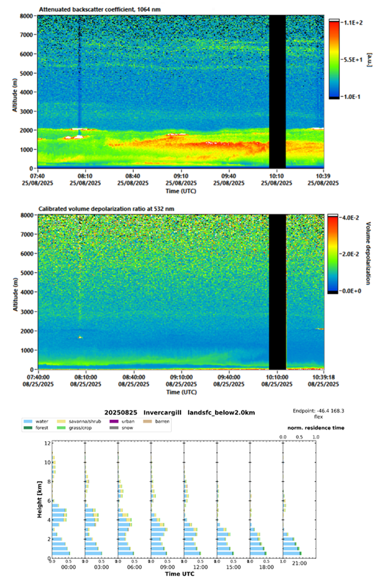
Fig. 1: 25 Aug 2025 Lidar attenuated backscatter cf. and volume depolarization ratio between 7:40-10:40 UTC.
Enhanced aerosol backscatter values in the planetary boundary layer are visible as well as lofted aerosol layers
between 2.5 and 3.5 km height (depolarizing) and between 5.5 and 7 km height (not depolarizing). TRACE data
shows a main contribution of aerosols originating from the ocean, however, the lofted layers have their origin in
savanna/shrub and grass/crop lands over Australia.
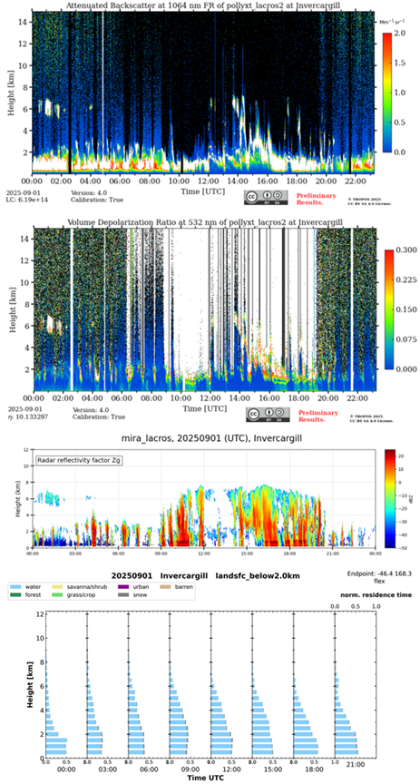
Fig. 2: 01 Sep 2025, very clean air, no lofted aerosol layers visible in the attenuated backscatter
and volume depolarization ratio measurements of the lidar. Many rain showers occurred during
the day, well visible in the radar reflectivity measurements. TRACE shows the dominance of
airmasses originating from water.
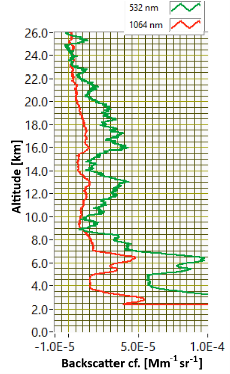
Fig. 3: Backscatter cf. profiles of Polly on 25 Aug 2025, 7:40-10:40 UTC.
Aerosol layer of volcanic origin is visible between around 9 and 23 km height.
After 4 months of shipping, on August 21, the Leipzig Aerosol and Cloud Remote Observations System (LACROS) arrived on the area of the New Zealand weather service MetService in Invercargill close to the airport. All measurement instruments survived the long transport and so setting up and starting the measurement devices went smooth and fast even in the cold and rainy shower weather of the southernmost tip of New Zealand.
With a public event that was held at the MetService site in Invercargill on 3 September, the campaign officially started. In the frame of the goSouth-2 project the measurements are planned to be run for 18 months. It is a joint project between German and New Zealand institutions. In the period between September 6 and October 11, the German aircraft HALO will accompany the measurements by flying over New Zealand and its surrounding with the on-board measurement instruments, for example the novel ice particle counter PINE-Air, that can measure ice-nucleating particles at temperatures down to –60°C.
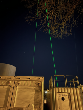
LACROS is equipped with an extensive set of ground-based and in situ instruments. Highlights are the portable lidar system (Polly), cloud radar measurements (at 35 GHz and 94 GHz), a radiation station, an ice-nucleating particle sampler as well as a particle size distribution sampler SMPS (Scanning Mobility Particle Sizer). The laser pulses, which form the widely visible lidar beam, that are emitted from Polly will be a prominent feature in the following one and a half years in Invercargill. During night, it can be visible in a radius of around 2km of the site.
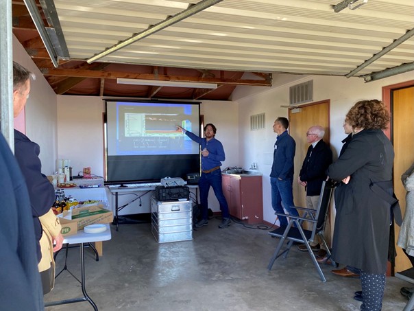
Ronny Engelmann from TROPOS, lidar expert and part of the goSouth-2 setup team introduces goSouth-2
to the audience of the inauguration.
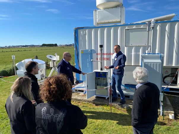
goSouth-2 PI Patric Seifert from TROPOS explains the instrumentation to the guests of the inauguration event.
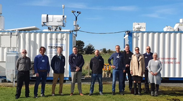
The setup-team of the LACROS station together with guests from different institutions from New Zealand.
Photo taken from https://www.linkedin.com/posts/regina-eisert_southland-christchurch-activity-7369201644640608256-_fpC
Preparation of goSouth-2 in New Zealand in its final state. After 4 months spent on the ocean and in the harbor of Bluff, setup of the LACROS observatory in Invercargill will start on the 21st August.
More than four months ago, on 17 April 2025, the journey of the Leipzig Aerosol and Cloud Remote Observations System LACROS to Invercargill started. On 21 August, the observatory will finally be delivered to its site on the area of the New Zealand weather service MetService in Invercargill, which will be its destination for about the next 18 months.
While LACROS was transported to New Zealand, the time without the need to supervise, process and analyze the continuous observations of LACROS was intensively used to prepare for the goSouth-2 campaign. Collaboration agreements between MetService and University of Canterbury were implemented, licenses for operation of the radar and lidar systems were obtained, and the infrastructure was prepared for the installation and operation of the LACROS instruments.
From Thursday the 21st August until 5th September things will get busy in Invercargill. Five members from TROPOS as well as partners from MetService and The Air Quality Collective will be on-site to install the instrumentation. The actual delivery of the three containers is planned for around noontime on the 21st August.
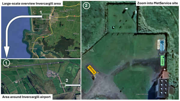
Map of the deployment site of LACROS on the area of MetService, south of the airport of Invercargill. The green rectangle marks the location of the container that houses the lidar system.
Immediately after the delivery of the containers, staff from TROPOS will start with the implementation of one of the key instruments of LACROS: The lidar system PollyXT. The near-vertical pointing green laser beam of this lidar system will likely become a prominent feature of the skyline of the nightly Invercargill. So far, similar green lights in the sky might have occurred only during the rare Aurora Australis events in this region.
PollyXT of LACROS at Leipzig shortly before it was packed for the transport to Invercargill.
The measurements of the PollyXT lidar will complement the existing datasets of PollyNet from other key sites of atmospheric research. While being basically similar set-up like a standard ceilometer system, PollyXT emits laser lights at several wavelengths. The fraction of the laser light that is backscattered to the lidar is then split into a total of 18 different wavelengths (channels), each of them holding a certain piece of information about the properties of the atmosphere above the lidar. While some of the channels solely provide information about the presence of aerosols and clouds between the surface and heights of approximately 20 km, other channels can be used to identify ice crystals, or cloud droplets, or certain types of aerosols.
Page 1 of 2